As published in the IAEM November 2018 Bulletin.
Trouble comes at us faster and more unpredictably than ever before, and time is never on our side during a disaster. If the wind changes during a wildfire, the whole scenario changes in an instant. Higher population densities make preparedness, response and recovery even more challenging. Old processes and antiquated ways of performing tasks add complexity to any event, and modern challenges demand strategically collaborative approaches.
“Better together” is the result of a partnership designed to address these challenges. Formed between industry leaders, Juvare and Esri, the partnership combines the WebEOC and ArcGIS platforms to help mutual clients respond more quickly and effectively in any emergency.
Delivering data in the visual context of geospatial maps gives organizations the opportunity to make more informed decisions and elevate information sharing among stakeholder organizations as well as the public. Independently, each solution only tells part of the story, but together, the visualization of incident data makes it possible to know where, when, and how to act. Emergency managers, as well as public safety professionals, depend upon a comprehensive picture of every situation. Without it, decision-making can be flawed and, in many cases, impact the safety of individuals.
Effective mutual aid decision-making requires data in context
Disasters test public safety agencies at all levels, and they almost always require mutual aid. But mutual aid requires the visualization of data to be effective. Responders and rescuers need more than a table of available resources—they need to know how close resources are and how fast they can get them. And they need effective ways to filter their data, so they can make precise decisions without distraction.
One such means for mutual aid will be the National Mutual Aid System (NMAS), assisting fire agencies with resource cataloging and sharing. Once agencies register with the International Association of Fire Chiefs (IAFC), they enter their inventory into a system which standardizes types of equipment and processes nationwide to assist with mutual aid planning and fulfillment. With this system, fire agencies can visually see where resources are available.
“We can no longer swim in a sea of data. The data I need to make a decision right now will be completely different than the data I will need in another minute to make another new decision even faster,” says Jeff Dulin of IAFC. He adds another important point, “Emergency managers and public safety professionals need to see data beyond borders. They can’t be limited to what they have, and they may need to bring in pre-existing or historical data and use it in a new context to make the right decisions”. Leveraging work that has already been done, and being able to visually see data in a new light, can and will significantly increase the ability to make good decisions faster and save lives.
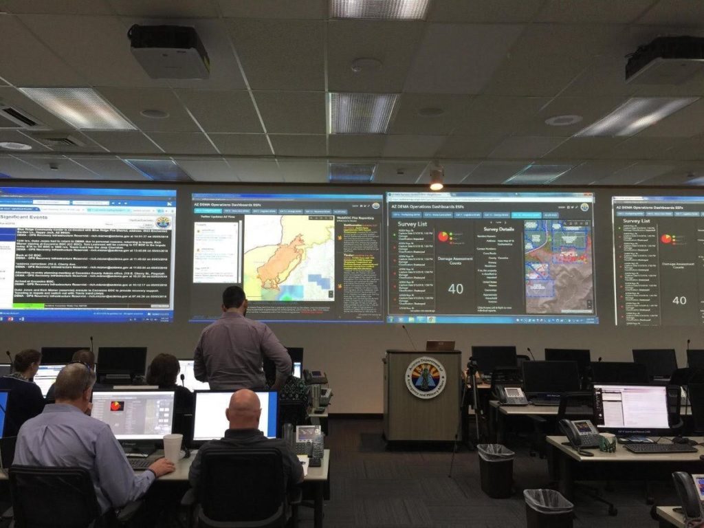
Arizona governor relies on data plus mapping for effective briefings
Governor of Arizona, Doug Ducey, wanted better access to emergency information in his state. During flooding incidents, he was getting information from all over the place and responding to ceaseless questions from countless people. He lacked true situational awareness, and it was interfering with operations. He knew there had to be a better way to communicate the whole story to stakeholders. And there was. With “Better Together,” the Department of Emergency and Military Affairs has been able to capture every activity in their emergency operations center (EOC) in one visual application.
“With WebEOC data and ArcGIS mapping, we now had a consolidated dashboard right in our command center and we could see everything that was going on,” says Eric Shreve, Arizona Department of Emergency and Military Affairs. “This took the burden off of the GIS unit, as personnel were no longer bombarded with questions about locations. Having a shelter status dashboard allowed us to add additional data sets into one application, such as feeding sites, food banks and donation centers.”
The governor then had all the information he needed. He could better communicate with citizens. They knew where and when to evacuate, which, in turn, helped save lives and property. And, importantly, emergency management could focus on the emergency at hand. A win-win for Arizona.

Citizens in Miami-Dade benefit from real-time updates
In Miami-Dade County, Florida, the public gets real-time relevant information in the palm of their hands during any emergency or incident. Using the same data-plus-mapping strategy as in Arizona, Miami-Dade repackages its emergency management data for public and stakeholder consumption.
By combining data and mapping, “We have the ability to ease the point of suffering in an emergency,” says Soheila Ajabshir, Miami-Dade Office of Emergency Management.
As an outcome of Hurricane Irma, Miami-Dade first put mapping and incident data capabilities in their mobile app. They’re sharing 18 WebEOC boards with ArcGIS, ranging from local mitigation project tracking to grocery and pharmacy openings, hospital availability, bridge status, road closures, debris management and more.
Now that maps and data are combined and made available to the public, local residents can look online to get a better picture of when and where resources are available to them. “When a shelter or evacuation center opens, people know which one is open,” says Ajabshir. “They know if it is a pet friendly shelter, the current occupancy and capacity, location, direction and more.” Every minute, WebEOC and ArcGIS Online data is synchronized for emergency management applications and the same data is downloaded to the County’s internal database every 15 minutes for redundancy and internal Miami-Dade apps.
Suitable for all stakeholders
What Miami-Dade response agencies need to see and what the public needs to see is vastly different, so flexibility in handling diverse audience needs is important. “We can choose, filter and synchronize data and expose it to different stakeholders,” says Soheila. “This is also an easy-to-implement tool. We simply build out the feature services from WebEOC boards. We also ensure redundancy by bringing external data for all jurisdictions into our internal database.”
1.7 million hits prove it’s working
Soheila knows what they are doing is working. “Our app got 1.7 million hits, so we know people are seeing the information in real time. The most important thing is the real time accurate data, and I’m using the system to its fullest potential.” When people get what they need, the likelihood of them calling 311 for information is reduced. This frees up time for critical response activities.
Improving business and operational outcomes
Together, the “Better Together” partnership enables organizations to:
- Reduce response times
- Provide resources quickly when they are most needed
- Make the most of available resources to have the greatest impact
- Increase mobile device workflows and ease of use
- Inform the public in real time with live access to information
- Ensure elected public officials are satisfied with high-level briefing information
- Enable emergency managers to stay on task as questions are addressed before they arise
- Save lives and property
- Understand the full potential impact on situation by seeing all areas that could be impacted by a disaster
- Eliminate work by breaking down silos and solving problems together that cannot be solved in isolation
“Visualization without data in context is just a pretty picture,” says Jeff Dulin. “When ‘where’ and ‘what’ match up, we have a process that enables people to solve problems.”
People are visual and seeing is knowing. Data and mapping are simply better together.
Click here for PDF of article as posted in IAEM November 2018 Bulletin.
Matt Cronin is a product manager at Juvare with more than 8 years of experience in emergency management. Matt was formerly an administration and finance manager at Palm Beach County Division of Emergency Management.