Skip to content
PRODUCTS
Close PRODUCTS
Open PRODUCTS
PRODUCTS
UCP for Federal & Defense
Secure Command Platform for High-Stake Operations
WebEOC Nexus for Critical Infrastructure
Operational Backbone for Critical Infrastructure
Juvare HealthSuite
Complete Operational Support for Hospitals, EMS & Public Health
WebEOC Nexus for State & Local
Cloud-Based Command & Control for Real-Time Coordination
Crisis Track
FEMA-ready damage assessment
BOARDS
Juvare Boards
Operational Backbone for
Critical Infrastructure
Click here
LOGIN
Request a Demo
Select Product to Log In
WebEOC Nexus
UCP Federal
UCP Defense
Crisis Track
EMResource
EMTrack
CORES RMS
CORES HAN
elCS
ADD-ONS
Close ADD-ONS
Open ADD-ONS
Native Add-ons
Juvare Intelligence
AI-powered business intelligence
Juvare Exchange
Collaborative incident management solution
partners
AirSight
SenseNet
Baron Weather
FleetUp
WeatherOptics
ICEYE
PowerOutage
partner with us
BOARDS
Juvare Boards
Operational Backbone for
Critical Infrastructure
Click here
LOGIN
Request a Demo
Select Product to Log In
WebEOC Nexus
UCP Federal
UCP Defense
Crisis Track
EMResource
EMTrack
CORES RMS
CORES HAN
elCS
Industries
Close Industries
Open Industries
industries
State & Local
Sporting & Events
Oil & Gas
Federal Defense
Federal Civilian
Electric Utilities
Aviation
Corporations
Education
Healthcare
Financial
Commercial
Transportation
Emergency Management
Manufacturing
Latest
Dec 16, 2025
Juvare Acquires Zapoj
Read More
LOGIN
Request a Demo
Select Product to Log In
WebEOC Nexus
UCP Federal
UCP Defense
Crisis Track
EMResource
EMTrack
CORES RMS
CORES HAN
elCS
Client Success
Close Client Success
Open Client Success
client success
Professional Services
Proven emergency management consulting and support
Client Training
Learn how to make the most of Juvare's solutions
Help Center Portal
Getting started, release notes and support
Support
Get in touch with our support team
Featured case studies
view all
Case Study
Nov 6, 2025
How Harnett County Emergency Services Uses Juvare AI to Optimize Operations and Save Resources
Read More
Video
Mar 10, 2025
Vicki Travis
Read More
LOGIN
Request a Demo
Select Product to Log In
WebEOC Nexus
UCP Federal
UCP Defense
Crisis Track
EMResource
EMTrack
CORES RMS
CORES HAN
elCS
Thought Leadership
Close Thought Leadership
Open Thought Leadership
Thought Leadership
Resource Hub
Essential tools and insights
Blogs
Strategic perspectives on operational resilience
Events
Join us at upcoming conferences and webinars
Press Releases
Latest company news and industry developments
Featured
Live Webinar
Jul 1, 2026
Webinar: Juvare’s WebEOC: Battle-Tested Platform, Reimagined for What’s Next
Read More
Blog
Feb 2, 2026
Continuity of Operations (COOP) Planning: The Ultimate Guide
Read More
Video
Jan 16, 2026
How Bird Electric Uses WebEOC for Storm Response and Power Restoration
Read More
LOGIN
Request a Demo
Select Product to Log In
WebEOC Nexus
UCP Federal
UCP Defense
Crisis Track
EMResource
EMTrack
CORES RMS
CORES HAN
elCS
Company
Close Company
Open Company
Company
About Juvare
Empowering resilience for a safer, smarter world.
Careers
Mission-driven culture, total employee support
Contact Us
Get in touch with our team
FAQs
Learn more about our company
other regions
APAC
Coming soon!
CANADA
Coming soon!
EMEA
Coming soon!
Featured
Dec 16, 2025
Juvare Acquires Zapoj
Read More
Follow us on our socials:
Linkedin
Facebook
Youtube
X-twitter
LOGIN
Request a Demo
Select Product to Log In
WebEOC Nexus
UCP Federal
UCP Defense
Crisis Track
EMResource
EMTrack
CORES RMS
CORES HAN
elCS
LOGIN
Request a Demo
Select Product to Log In
WebEOC Nexus
UCP Federal
UCP Defense
Crisis Track
EMResource
EMTrack
CORES RMS
CORES HAN
elCS
LOGIN
Select Product to Log In
WebEOC Nexus
UCP Federal
UCP Defense
Crisis Track
EMResource
EMTrack
CORES RMS
CORES HAN
elCS
Request a Demo
Back
Standard
Board
Standard
Board
Standard
Board
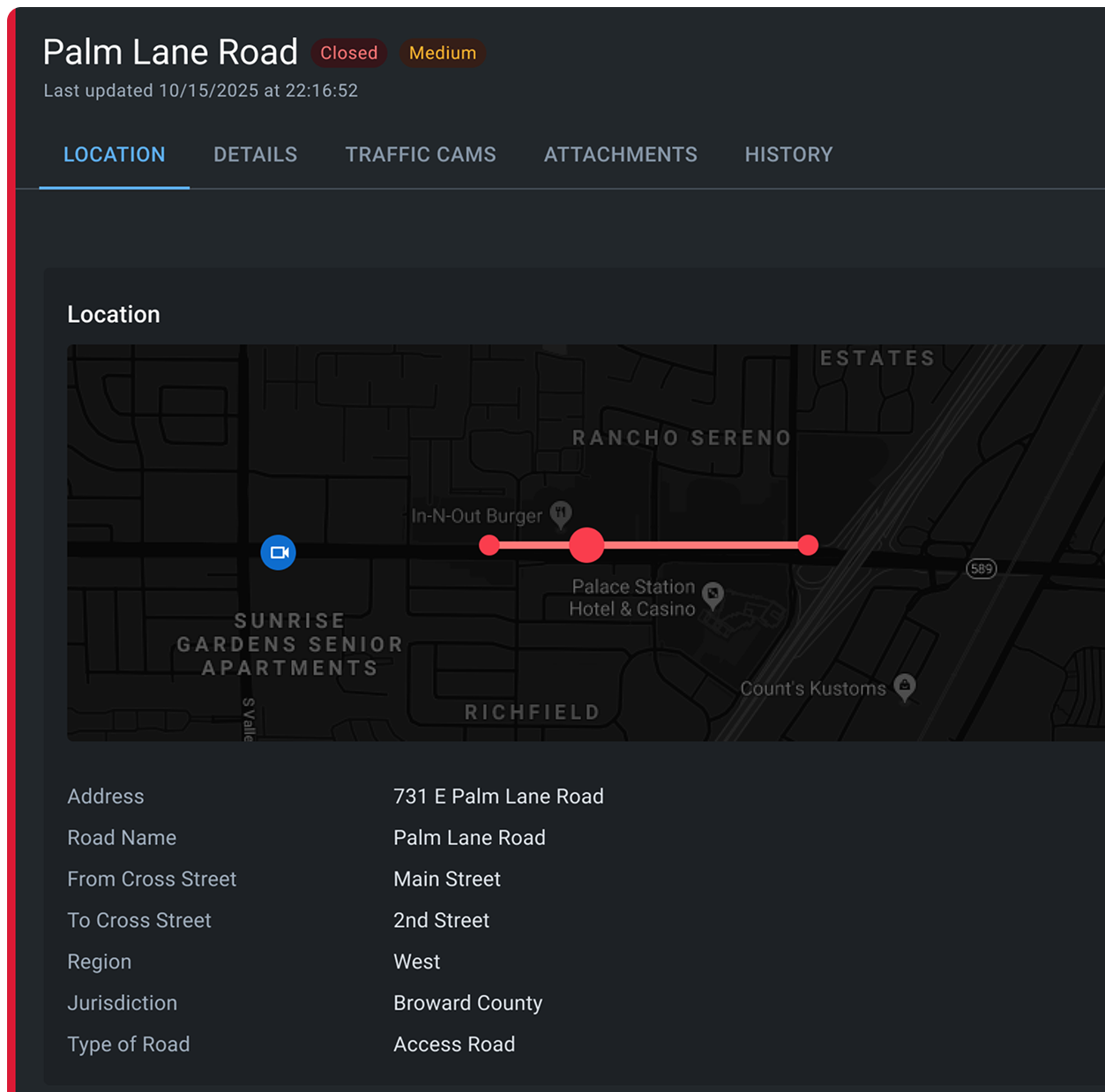
Road Closures
Track road closures, detours, and transportation impacts during incidents. Visualize affected routes on maps and coordinate with agencies to restore access and maintain public safety.
Talk to an Expert
Applicable Industries
Aviation
Corporations
education
Electric Utilities
EMERGENCY MANAGEMENT
FEDERAL AGENCIES
GOVERNMENT DEFENSE
HEALTHCARE
PUBLIC HEALTH
OIL AND GAS
RETAIL
STATE AND LOCAL GOVERNMENT
TRANSPORTAT ION
Comprehensive post-incident analysis and reporting capabilities
our solutions
Key Capabilities
Interactive Closure Mapping:
Display road closures and detours on interactive maps for clear situational awareness.
Closure Details:
Document closure reason, expected duration, alternate routes, and responsible agencies
Public Information Integration:
Share closure information with public information officers for community notification.
Multi-Jurisdiction Coordination:
Enable transportation and public works agencies across jurisdictions to collaborate on closure management.
Discover How Road
Closures Can Transform Your Business
Request a Demo
talk to sales
Search
Search
Search