Facilitate seamless communication and collaboration across your entire organization and with external partners. WebEOC provides robust, multi-channel communication tools designed to ensure timely, targeted information exchange during any critical event.
LOW-CODE/NO-CODE WORKFLOW BUILDER
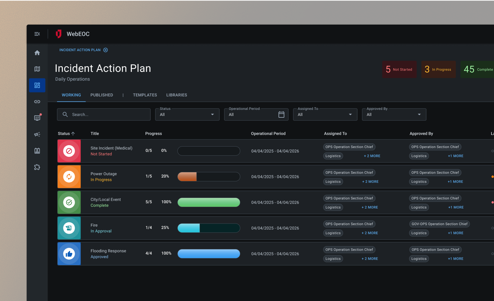
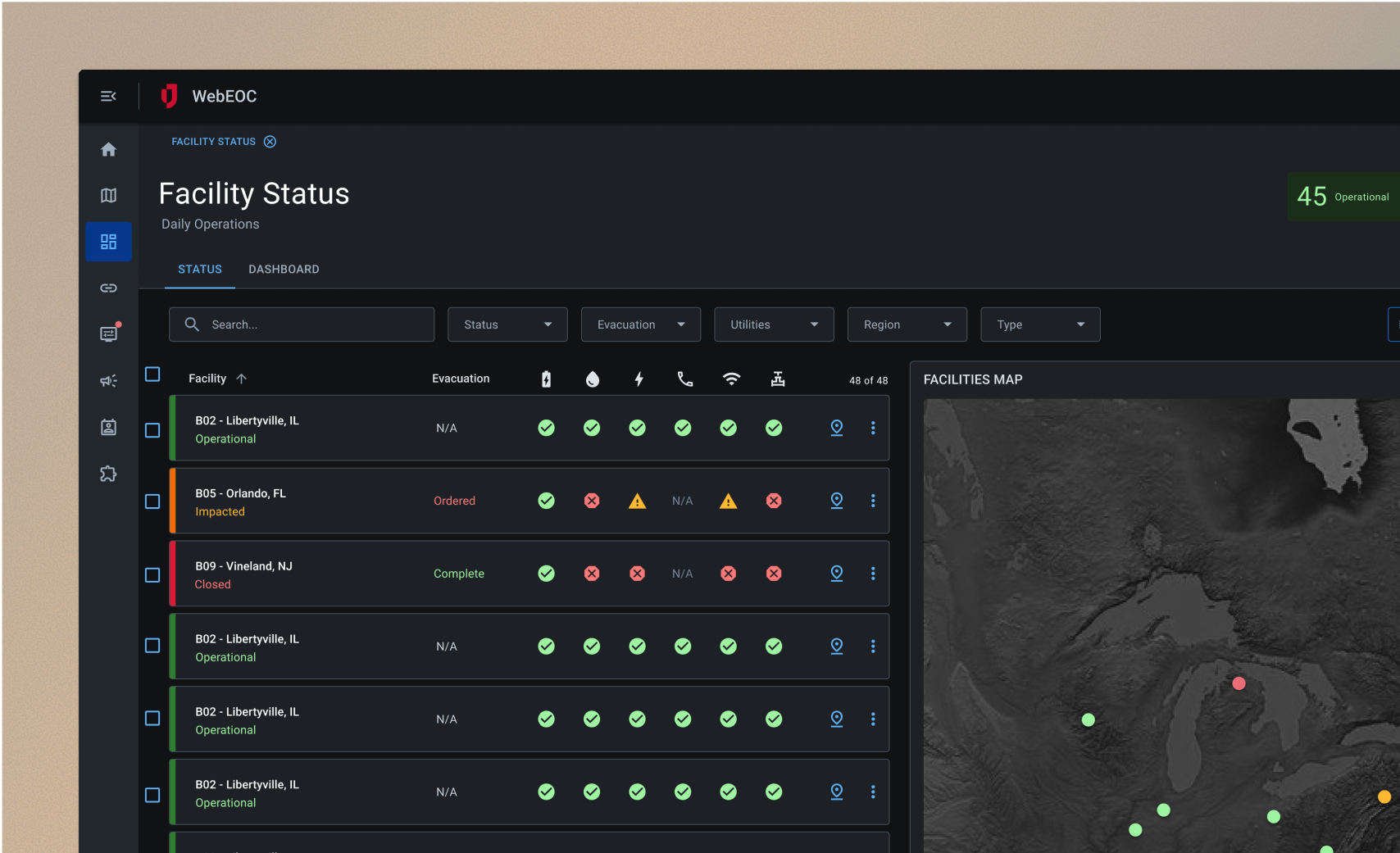
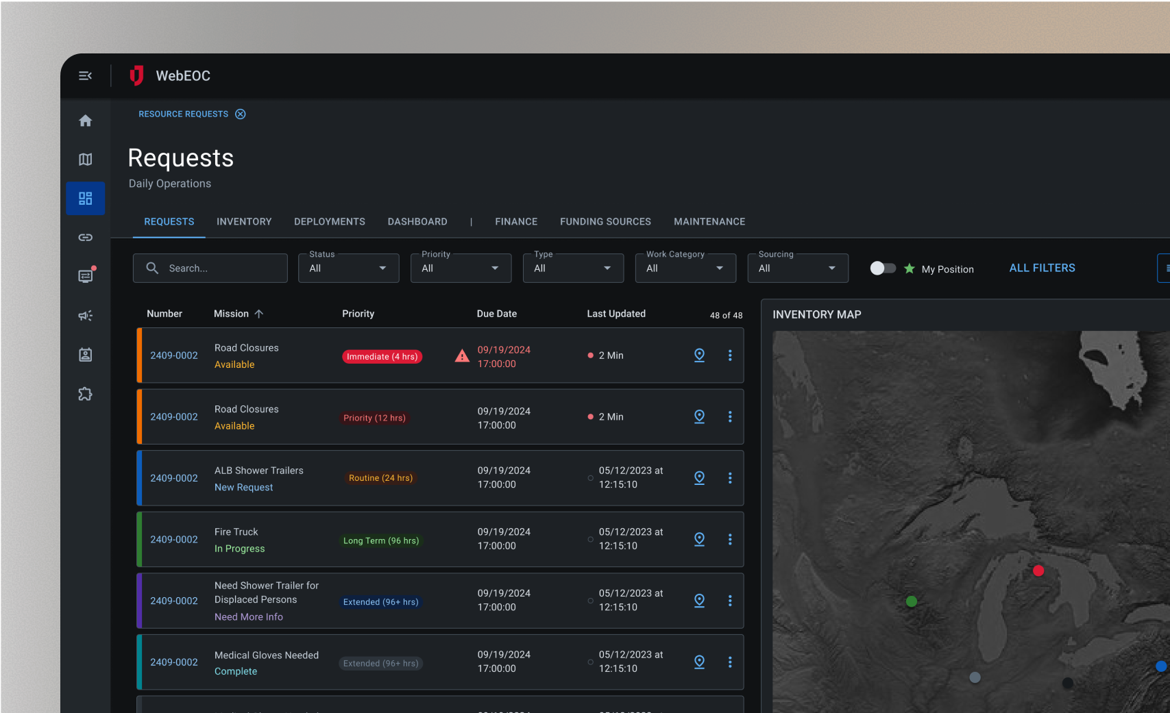
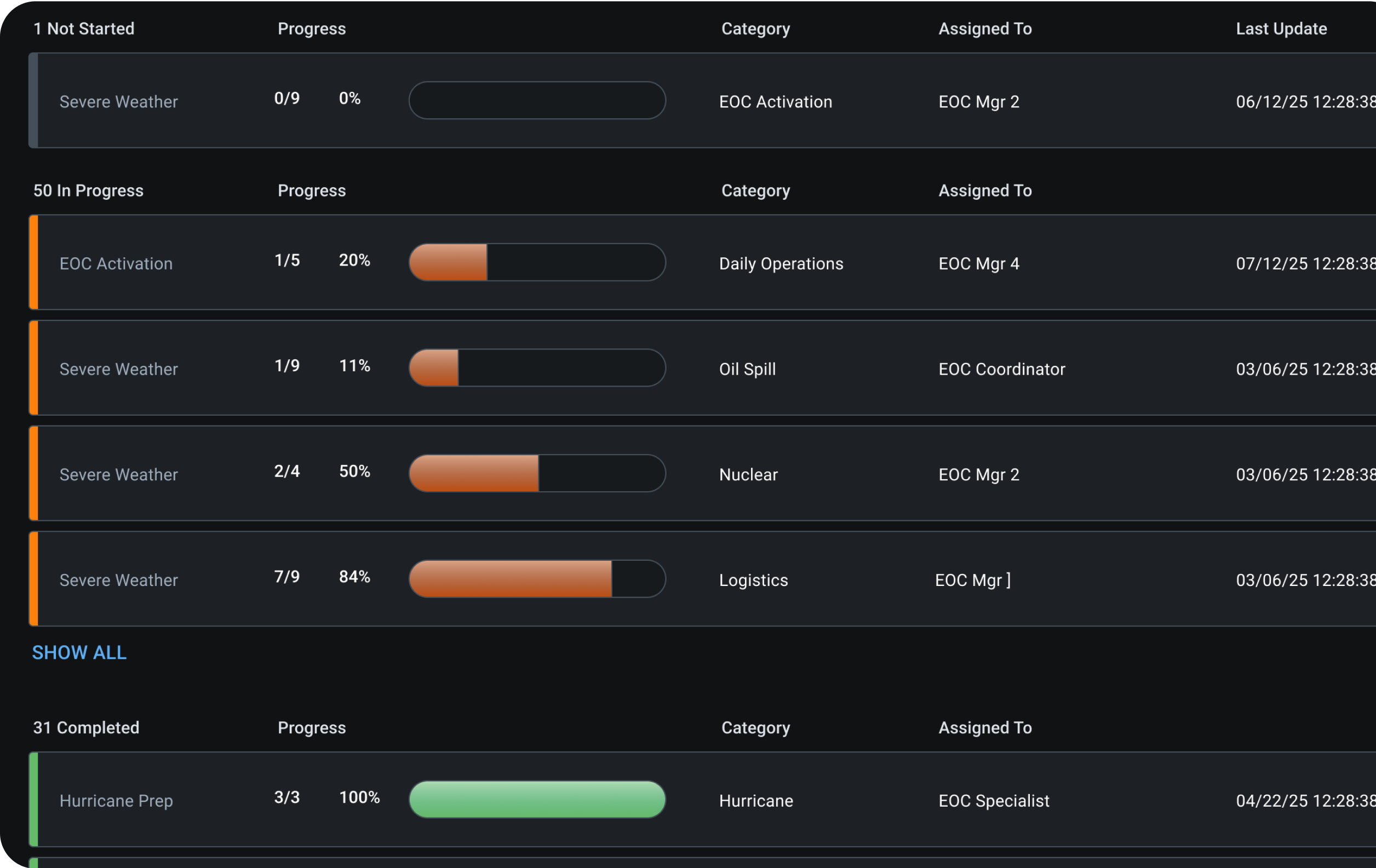
Configurable data intake and workflows to meet your org-specific needs
Low-code/no code workflows: design boards tailored to your particular operations
Forms made easy: simplify form creation with drag-and-drop controls
Public data capture: create and deploy forms to collect info directly from the public
Offline forms: work offline with forms that auto-sync when connection is restored
Dashboarding and reporting: summarize data with built-in charts and graphs for actionable insights
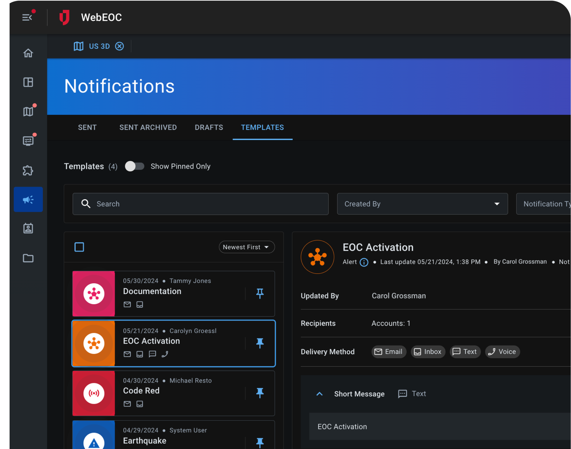
Multi-Channel ALERTS & NOTIFICATIONS
Direct messaging that lets your team act fast and stay ahead
Deploy urgent alerts across multiple channels simultaneously – text, email, Teams, Slack, or voice calls. Set up automated notifications that trigger instantly when conditions change, or send manual alerts when critical situations develop.
Mobile App
Track Objective Completion in Real-Time
Your ground teams update task completion directly from their mobile devices, creating an instant flow of information from the field to your command center. Leadership sees progress as it happens, not hours later through delayed reports.
Juvare Exchange
Secure and Encrypted Communication with External Partners
Share sensitive information instantly with external agencies, partners, and vendors through encrypted channels, ensuring secure multi-agency coordination without compromising security or slowing response times.
Rarely have we been told ‘no’ when asking if something is possible, which speaks to the strategic thinking and adaptability of Juvare’s team. Every challenge we faced was met with a thoughtful solution, and they have been invaluable partners in helping us create a best-in-class security operations platform.
Assistant Director, Physical Security
40,000+ seat professional sports stadium
Trusted by
48 of 50
U.S. States
93%
Client Retention Rate
Used by
4,000+
Organizations Globally
Configurable Business Continuity Planning Software
Flexible Workflows That Adapt to Your Business
WebEOC adapts to how your organization works. Its flexibility allows you to easily create and modify workflows that perfectly match your specific procedures, ensuring the system truly fits your operations.
Custom Workflows Made With Drag and Drop
Design Studio’s no-code environment puts configuration control directly in your hands. Build and modify WebEOC to match your exact operational needs without requiring technical expertise.
Pull Insights Relevant to You
Configure smart insights that work for your specific needs. JAI, our AI assistant, learns your data patterns and creates customized summaries for your stakeholders, while Juvare Analyze provides configurable visual dashboards that display the metrics and trends most important to your operations.
WebEOC’s flexible connectors work with CAD systems, HR databases, GIS platforms, and maintenance software. Configure the connections that make sense for your workflow, ensuring WebEOC enhances your current processes instead of disrupting them.
Get Support From Industry Veterans
Our experts help you get WebEOC working exactly how you need it. We’ll design your workflows, build custom forms, set up integrations, and train your team.
Keep Operations Running When Everything Else Stops
WebEOC ensures your critical operations continue functioning even when normal processes are compromised, protecting revenue streams, and maintaining service delivery during challenging circumstances.
Maintain Essential Functions During Disruptions
Keep your business running smoothly even when disruptions hit. Whether it’s supply chain interruptions, facility closures, or staff shortages, you can quickly pivot operations and maintain service levels that keep your business running.
Rapid Recovery Planning and Execution
Pre-built recovery workflows activate instantly when disruption occurs. Your teams know exactly what to do, who to contact, and which processes to prioritize.
Documentation for Compliance and Insurance
Automatically capture detailed records of disruption impacts, response actions, and recovery timelines which can then be used for insurance claims, regulatory compliance, and post-incident analysis.
Juvare Intelligence Suite
Secure AI-Powered Insights and Reports
Juvare’s Intelligence Suite cuts through data noise to deliver clear, actionable insights with federal-grade security
Get quick insights and real-time summaries, transforming raw data into mission-critical intelligence within seconds
Secure
Our robust security ensures your mission-critical operations are protected; you control all data sharing with a role-based opt-in model, guaranteeing zero compromise.
Intelligence Sharing
Multi-channel collaboration breaks down silos. Chat, share files, sync boards, and integrate critical data feeds with external partners.
Case Studies
Read how WebEOC Transformed Crisis Response for Our Customer
95%
TIME SAVED
Streamlining Air Incident Response
PROBLEM
Airline needed to coordinate passenger reunification after incidents while keeping families updated in real-time.
Solution
WebEOC streamlined communication between internal teams and families, ensuring timely updates while meeting FAA requirements.
Enhanced Situational Awareness for Every Disruption
Juvare connects you to the data that matters—whether through trusted third-party providers or directly from your own systems. Juvare works with a wide group of service providers to ensure you always have the information you need at your fingertips.
Watch quick demos showing how each platform handles real scenarios, from daily operations to critical incidents. See the workflows, features, and interfaces that keep your teams coordinated when it matters most.
Business continuity software like Juvare’s WebEOC is a digital infrastructure that ensures an organization’s critical functions remain operational or recover quickly during significant disruptions. WebEOC for the private sector also combines tools for day-to-day operations with capabilities for emergency response, business continuity, and operational coordination before, during, and after disruptions and emergencies.
Is there a business continuity software that integrates with other enterprise systems?
Yes! WebEOC supports integration with enterprise resource planning (ERP), HR, and communication systems via APIs for seamless data exchange.
How does business continuity software aid operational continuity?
WebEOC provides workflows that help teams manage resources and incidents effectively. It also boosts situational awareness through shared dashboards, reporting, and alerts.
How do we keep our data safe while using business continuity software?
Use a platform like WebEOC that adheres to strict security and compliance standards, including role-based access and encryption. Juvare also holds the following ISO certifications: ISO 27001, ISO 27017, ISO 27018, ISO 27701, and ISO 22301. These certifications ensure that corporate data is encrypted, monitored, and protected against emerging threats.
How can private-sector users receive training on business continuity software?
Juvare provides flexible training options tailored to corporate needs, including instructor-led sessions, virtual workshops, and self-paced online courses for both end users and system administrators.
Thought Leadership
Read More About Juvare, Critical Operations Software, and the Work We Do
From pandemic response to election coordination to large facilities management