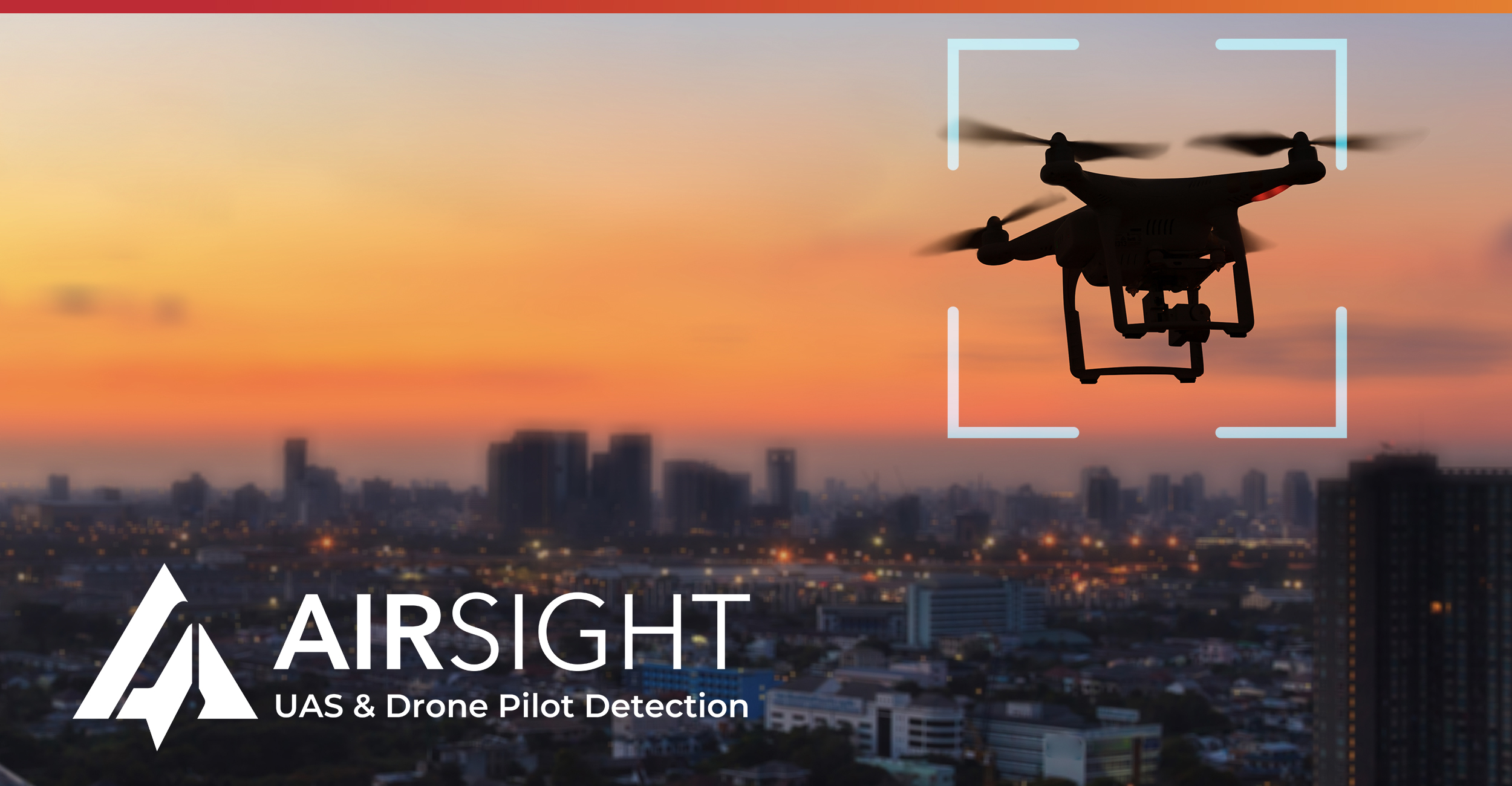
Get caught up on our joint webinar with AirSight to see how integrated drone detection and situational awareness enhance security and emergency response. In this session, experts break down the rising impact of unmanned aircraft on critical infrastructure and demonstrate how combining AirSight’s real-time drone intelligence with WebEOC enables faster threat identification, smarter decision-making, and stronger operational resilience. Watch the replay to learn how your organization can stay ahead of emerging risks with a unified, proactive approach.
TRANSCRIPT
Welcome everyone to our webinar titled securing the skies, protecting what matters, drone detection for people, assets, and infrastructure.
Before we begin, just a few housekeeping items. Today’s session is being recorded and will be shared with all the registrants after the event.
All attendees are muted by default, which will minimize our background noise.
For questions, submit questions anytime via the q and a panel. We’ll address them live as time allows and follow-up with direct directly on any we missed. There’ll also be a q and a session at the end of the presentation, so please hang around for that.
Tech support, if you’re experiencing any technical issues, try refreshing your browser or simply leaving and rejoining the session.
We’ll have two poll questions today. We’d love your feedback on these questions. We keep them very short, less than a minute each, so love your input there. The whole event will be about forty five minutes, including questions. And after the event, we’ll send a recording, the poll results, and a short survey to all registrants.
Today’s agenda, we’ll welcome today’s speakers.
We’ll have an introduction to our partner, AirSight. We’ll see the overview and benefits of AirSight, and then we’ll get a demo of AirSight, which is pretty impressive.
After that, we’ll have a demo of AirSight integrated with WebEOC. Very cool, all under one unified solution. We’ll talk about our future webinars, how to learn more, and finally, we’ll wrap up with any questions.
Today’s speakers, Charles Chip Dick is director of sales at AirSight. Matt Cronin is VP of solutions engineering here at air at at Juvari, and I’m director of partnerships at Juvari.
Before we jump into this first slide, let’s do a quick poll.
Okay. Our first poll question. How prepared is your organization to detect and respond to unauthorized drone activity near critical infrastructure or event venues?
Oh, great feedback.
Twenty seconds or so to get your responses.
Just sec. No. Still coming in.
Excellent. Thank you all for responding. We appreciate your input.
With that, I’d like to turn things over to Chip. Chip, take it away.
Thanks, Jeffrey. Appreciate that.
As Jeffrey said, I am Chip Dick. I work for AirSight and wanna give you a little background about AirSight. AirSight actually started as a physical security company back in about two thousand two.
For those of you who are familiar with AirSight, it actually started as nine one one security cameras or nine one one security. And then starting in about twenty eighteen, our founder, Robert Tavaro, was looking basically into the future, if you will. He saw that there was going to be a threat from drones and that what was needed was the ability to be able to detect those drones. So what he created was AirSight, which is the US based provider, and we do not only drone detection but pilot detection.
The platform name is AirGuard, and it delivers that airspace visibility. And we accomplish that by fusing the data from multiple sensors into an interface to give you that single command and control interface, if you will. So what we’re trying to do is detect, track, and respond to drones and trying to be as proactive as possible. Unfortunately, we’re often very reactive to events and things that happen, we all know if we can be more proactive, we can prevent them. So we work with both the public and private organizations across the US trying to give that enhanced situational awareness to reduce some of those blind spots. We want to be able to provide information that’s actionable, an actionable intelligence because the drones are increasingly being weaponized and used for nefarious purposes throughout the world.
So one of the things if any of you are familiar with physical security, what you’re always doing is you’re always evaluating. You’re always trying to see if you have a security gap. Traditionally, it’s been, do I need a better door, a better lock, a better alarm, a better access control system? And that is very two dimensional from about fifteen foot down. But now what we’re seeing is the huge security gap is the airspace.
It remains totally vulnerable because we’ve never had to look at it before. Drones are easily able to bypass conventional security measures.
Again, in that blind spot, that unprotected dimension is the gap, and that’s what we’re trying to fill. We see all the time drones being used to drop contraband into correctional facilities. We see them doing surveillance and even counter surveillance of operations or locations, cyber attacks. And to make sure that you have that modern security, you have to start looking at that third dimension, which is the airspace.
So how do we get a complete awareness system? Well, what was developed is a cloud based SaaS solution.
So we started a software, then we have to say, okay. What hardware do we need? Well, we’re very hardware agnostic. That gives us the ability to go out and pivot.
If there’s new technology tomorrow, I can promise you, our founder’s buying that sensor, and we’re testing it next week because we’re able to pivot. We all know technology changes very fast, so we have to be agile and able to adjust to it. We have a very modular system. It allows you to start at a certain level if you want to build up.
It’s kinda like Legos. You can build to the system you need. So it’s very customizable to the end user. We’re constantly upgrading our library software, any technological advances that we need to deal with.
And then to the end user, we provide that easy setup, installation, and training, and then we marry that with a twenty four seven monitoring system.
So how it kinda works? The three pictures do a good job of explaining it. We’re gonna have sensors. That’s the hardware that we’ve chosen and does the best for us.
Then we’re gonna install it, be it on a rooftop, a fence, or a pole. And what we’re looking for is that vantage point or that visual line of sight so that we have the best coverage. You don’t want obstructions. You don’t want things blocking where the RF energy or the visual recognition could be done.
And so then once we get those deployed, the sensors are running twenty four seven. They are constantly scanning for drones to give you the real time data through the AirGuard platform so that you can see it again, detect, track it, and be able to respond and be proactive.
So I kept talking about enhanced situational awareness. This is a snapshot, and I’ll show you more in just a few minutes of the system.
But this allows you to go in and look at your area holistically to see, hey. What does my heat map look like? What are the flight times that are going on? Where do I have the most flights? You can filter it by different locations, a multitude that makes it very customizable to the end user. And one of the newest enhancements you see is the nationwide search because not only can you look for previous flights of a drone in your area, if you know it’s a bad actor and it’s important, we have the capability now of looking through the entire AirGuard system in that nationwide search.
So what are some of the features and benefits? Well, we are basically very tier based because everyone’s need for drone detection could vary. As you can see, we go from a basic to an essentials to an enhanced to a complete, and each one goes up as you go up the chart with its capabilities. Not everybody may need the complete with the radar, but everybody may need more than the basic.
So it is very modular. And if you start at one level, you can easily upgrade to the next level. One of the things I would like to note on the bottom, my error, the visual camera integration on the complete system, that is included. It is not an add on.
And then as you’ll see on the very bottom line, our WebEOC integration is one of our newest, and I believe one of a very exciting enhancement we’ve done partnering with Javari and the WebEOC. And I don’t wanna steal Matt’s thunder, but he’s gonna get to more of that in a little bit.
Alright, Jeffrey. I’m gonna share my screen, and I’ll jump over into the interface.
So if you would, tell me if you can see, like, a US map.
We see that, Kip.
Alrighty.
This is basically as many of you can probably pick out is the outline of Louisiana. I use Louisiana because they are probably one of the most aggressive states in drone detection and creating a network, if you will. Florida is very strong as well. In both of those states, we probably have twenty five plus sensors.
But I’ll use Louisiana today. And as you can see, we’re in live mode right now, and we actually have drones flying. Let me just double check and refresh this and make sure, that we have drones flying in the system or just flew or flying now. So I will pull up this one.
And as you can see, this is a drone literally flying in real time as we’re doing this webinar. And over here to the right, you start to get the information of the drone. You see the flight time because it’s counting up because that’s how long the drone has been in the air. And then you’ll notice it starts to give three different locations, a drone, a pilot, and a home location.
And even down not only a street address, a lat and long.
The lat and long was actually an addition because of end user feedback because often a street address might actually cover a large geographic area. So saying one two three Main Street could be a hundred acres. And so when people are trying to respond, especially to the pilot or where the drone is, we were able to add the lat and long to give you within about three to five meter range so that you can go look for either the drone or the pilot. To the right here, you’ll see the profile tab, and what that does, it starts to provide even more information. So the unique drone identifier is there so you can know with certainty. Should you ever recover a drone that matches that, you know the flight that that drone was on.
So you see that there’s only two here because those are the two drones flying live. So you may be asking, well, what happens when they’re not flying live? Well, everything then becomes a record because we’re documenting and we’re recording everything. So we will go into the records, and we will look just for the last seven days. And you’ll notice down here, it’s page one of a hundred and eight.
Each page has twenty flights on it, so you have to multiply that by twenty. So in the last seven days, we know there’s been two thousand one hundred and sixty flights that we have been able to detect through our Louisiana network.
Now what becomes interesting is if you take that to a hundred and twenty days. And this is gonna take a minute because it’s pulling a lot of data, and I already know the answer because I looked at it earlier. But you’re gonna have over fifteen hundred pages of data. So when you do the multiplication, that times twenty, over thirty thousand flights.
So fifteen twenty two, so thirty thousand four hundred and forty flights that have been captured and documented. And, again, when these are in records, you can go and look at the same information. You can go back and look at the flight path. You can zoom in and go over any of the information that we’re able to capture.
Again, the drone ID.
And one of the things I should have started with Just a quick question.
Attendee wants to know if the information is based on a remote ID from the drone, how is that information pulled in?
So in, in our Louisiana network, we have multiple sensors. We have multiple customers.
So, yes, part of the data could be coming in through a remote ID. It could be coming in through library based sensor, or it could be a radar detection.
And if it is a radar detection and we’re seeing it instead of hearing it, then we would not have the unique identifier because it is a drone that’s actively trying to circumvent detection and is not transmitting remote ID as is legally required if it’s over a two hundred and fifty gram drone.
And I see the next one is what are the sensors sensing? The RF sensors are passive, and they’re listening for the RF energy going between the drone and the controller. So it’s listening to anything it can detect as far as the frequency. In the radar setup, the radar is then looking, and it is tied and married to a PTZ camera. So it will detect the flight motion, then a camera and the sensor or in the radar will then determine through two different algorithms confirming that is indeed a drone. And like I mentioned earlier, with our radar, we also have a live monitoring system. So we have a human that puts visual eyes on that flight path and of that picture and confirms so that you don’t have false positives with radar, which could be a bird, could be a bag, could be anything just moving through the air.
So as you go through the records again, you have over thirty thousand flights. And what I was about to say is the blue line is basically the default zone of the system, So it’s picking up anything it can there. And then you see the red area. That is an alert zone. And, basically, it’s like a geofence. So if one of these drones crosses that geofence, that’s when the system can give you an automated alert that there is a drone flying in your airspace that you either wanna be aware of or is unauthorized or you need to know for some reason.
So you can take this the next step. We know there’s a bunch of flights, but we can look at the analytics like you saw in the snapshot on the one slide. And here, just in the last week, you see the heat map of all the flight time of the drones. But what what is concerning is that in just the last week alone, we showed that four hundred and forty five were over the four hundred foot FAA guideline.
And then we also see that seven hundred and forty four of them flew outside visual line of sight.
Now that’s bad because they’re doing things that they’re not supposed to. But when you take this back about two months, what becomes scary is that goes to twenty nine hundred flights that are over four hundred foot, forty two hundred flights that are outside a visual line of sight, and those start to create threats. If you’re over four hundred foot, you’re in the airspace of low flying aircraft, rotor wing, your medical, helicopters, people responding to emergencies. And if you’re flying outside of visual line of sight and you cannot see your drone, you don’t know if anything could interact with your drone, crash, or you could cause something to crash.
I think it’s what frequencies the typical two point four, five point eight, depending on the frequencies we are looking at for the different what we believe drones to be transmitting in. Along with those, we’re also aware that people might do a DIY drone and try to do a frequency shift that’s outside the normal spectrum, but that’s then the importance of having the radar capabilities. So if they’re trying to circumvent a frequency that we can then also see them.
And Mark had a question. Does the overlay filter also provide details about restricted flight areas?
It does not by default, we could draw a TFR on it if you have one in just like the red alert zone, but I think you’re gonna see with WebEOC, you’re gonna get some enhanced capabilities there as well.
And so I’m gonna move forward and let Matt talk about that here in just a second. But, again, going back to the analytics, you could see I could filter by a pilot location. I could filter by takeoff and landing locations, and I get just a wealth of information. One of the things I wanted to show in records let me jump back over here real quick, and I will pull up one more flight.
And I’ll there it is. So we also have the ability, like I said, to identify, but we also have a share feature. So if I need to send this specific information to maybe somebody responding to a pilot or at a public event where it needs to be immediate, I can go in and type in the phone number of who I want to send it to and basically send it as fast as a text. I mean, it’s almost instantaneous.
But I will take a quick pause there and see if there are any other questions that I missed. I think we covered the one about the remote ID.
Know that sensors are not limited to line of sight.
In our traditional RF sensor setup, we will go about two to three miles omnidirectional.
And the thing you would have to look at is RF can be interfered with just, I use the analogy, you could be in a downtown dense area, lose a cell phone call. Well, the same thing with the RF. It’s it’s very dense. Sometimes the coverage is not as great, but it is not restricted to line of sight.
And, Colin, I’m gonna save your question for Matt when he comes up. But are there any other questions regarding the interface or about drone detection with me?
Hey, Chip. Just one that came to mind while you’re presenting. You you mentioned that the sensors can be on top of a building or, you know, on a pole. Can they also be on a mobile, trailer?
Yes. Great question. I apologize. I should’ve covered that, the capabilities. We do have a, a mobile trailer solution, which gives the ability, to move to special events, to move to different threat areas.
It can be run by solar. It can be run by shore power. You could even run it by a generator. The way we set up the trailer is with solar, but it does give you that versatility to have the mobile abilities to move from, like, one special event to another.
Fantastic.
Thank you, Chip. I’m gonna go ahead and take back the presentation. Alrighty.
Chip, there’s a couple more questions here I think we can jump on.
How about restrictions close to the southern border?
If we’re operating within the US, we’re gonna detect we could detect across the border, but I don’t know that there’s any restrictions in that.
Jacqueline’s question, can it detect anything being carried by the drone? If we are using a PTZ camera, if you had added that to the, as an option, yes, you can the camera will marry to the point and give you a visual image of the drone as it tracks it in, and then you can usually tell visibly if there is a payload attached to the drone.
Hey, Chip. Let’s hold the rest of the questions to the end just to make sure we have enough time, if you don’t mind.
Perfect. Thank you.
Thank you. Okay. We’ll move on to our next presentation from Matt. Before we do that, I’d like to pop in one more poll question, and this is the last one. What is your biggest challenge in integrating drone detection data into your command or operations platform?
And I’ll give you, about a minute to answer that one. We really appreciate your feedback on these questions.
Do a few more seconds. Thank you all for your feedback.
Excellent. Thank you all for your response. We’ll go ahead and close that poll out, and we’ll turn things over to Matt. Matt Cronin, Matt, please take it away.
Thanks, Jeff. So, yeah, great discussion so far. Great review by the AirSight team. I wanted to talk a little bit about the integration that we’ve created with AirSight.
So with that integration, have that ability to really take the data coming from AirSight, bring that directly into WebEOC to, you know, have insights by all your WebEOC users. So you can assign that to the folks that need it. It centralizes that threat information and visuals into WebEOC. I’m gonna I’m gonna show that in a moment.
Really allows you to, you know, respond faster for the folks that have some responsibilities related to these sort of situations.
You can take those records, can create requests from them, you can create event logs from them, and really just enhances that security and readiness by bringing that information in, seeing the information as it relates to the location of critical infrastructure, maybe other, you know, personnel or other locations that are applicable. So, yeah, let’s go ahead and dig into it and show you what we’re talking about in with the WOC integration. So I’m gonna go ahead and share my screen.
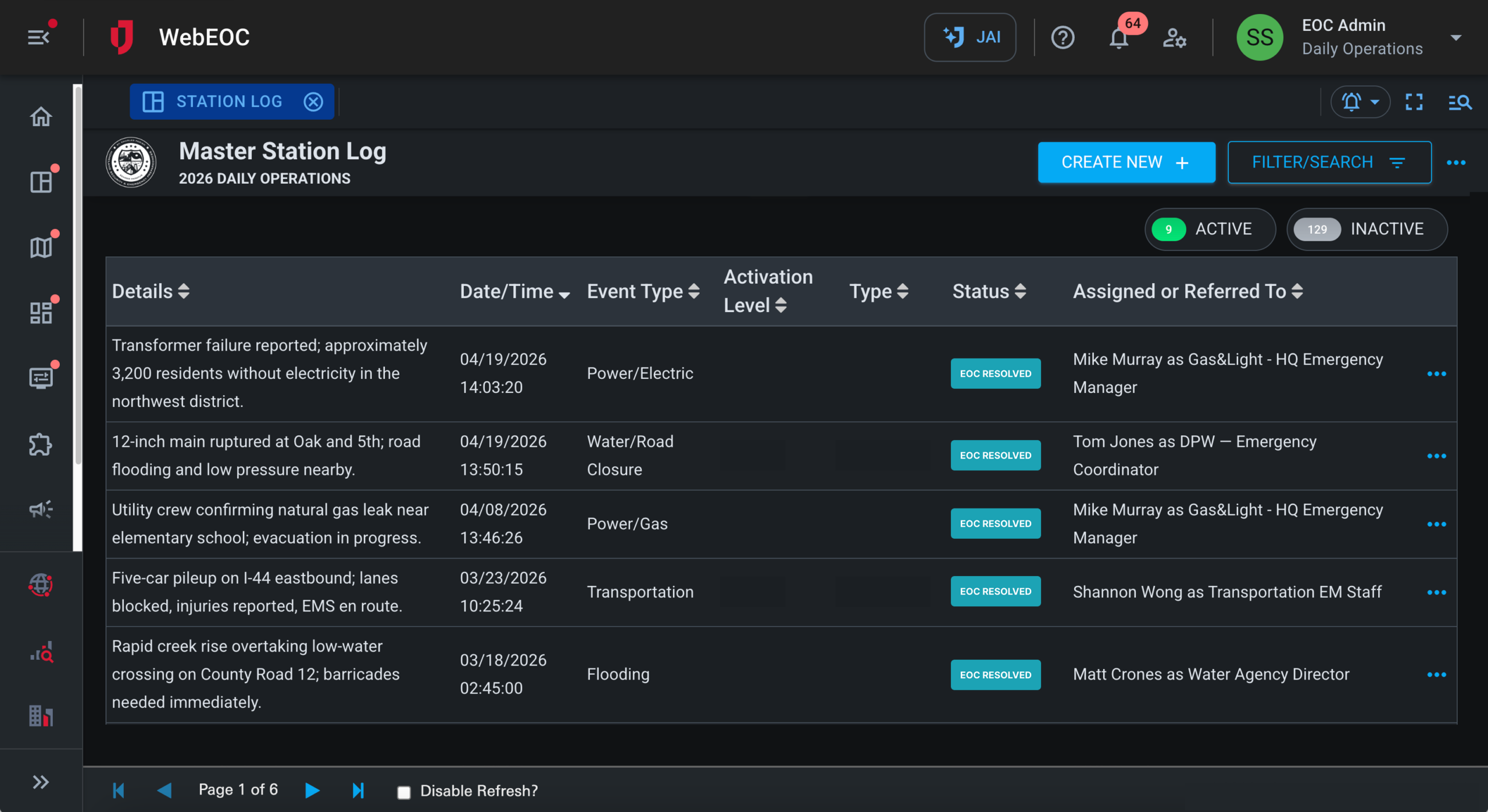
So what we’re looking at here, if some of you aren’t familiar with WebEOC, we’re looking at WebEOC Nexus, so the latest version of WebEOC. You have some abilities to have home pages, which can in this case, I brought together a number of different resources related to AirSight. You know, you can have links to external sites. So, you know, the AirSight site, our partner site, you can link out where you need to.
You can link to to maps. I’m gonna open up the map in a second. You have your other workflows like your requests and your events that have been logged. In this case, I’m gonna shift locations to kind of the the the Chicago area.
So we have, a number of events that have been logged in in this area. We have our resource requests and dashboards for that. And of course, what we’re really here to talk about is the air site data. So we have a workflow that allows for grabbing that air site data.
What we’re looking at here is just the we’re looking at the Chicago area.
We have this is flights just within the last twenty four hours. So if you scroll down here, you see the some key information. How long ago? Obviously, they come in as as they occur.
When they occur, you know, AirSight has some alerting capabilities. Obviously, WebEOC has some alerting capabilities too. So when those alerts hit WebUC, you can also trigger an email alert or text message as well. We have those capabilities as well.
So in this case, for this last one that came through, you can see, you know, what type of drone it is, the altitude, how long it flew, even a kind of a report attached to that email just to show the the key details of that particular flight. So that would be automated and come right to your email for those that that need it. But what else do we have here? We have just come from a UI interface standpoint.
We have the ability to go to dark mode. So a lot of folks like to use that in kind of at night, you know, low light environments.
So you have that ability to switch between dark mode and have the ability to see, again, that map interface. So where are these particular flights occurring?
Again, they’re sorted by the time from from when they occurred. If I want to, I can drill into a particular flight and see, you know, all the details about that are coming from AirSight’s great technology. So the altitude, the speed, the type of drone, that ID, which is critical because if you’re looking at, you know, maybe some concern about a particular drone, you’re tracking that over time and you can search that particular ID and it will show you all the flights that took place with that particular drone and pilot. As you drill into the map down here, you can see, you know, where that drone took off, where that pilot was, the path it took, all within an interactive map here.
You can also, at any point, you could, you know, export to PDF, a detailed record, or from this main video that you’re wanting to, create a report. You could at any time, of course, export to PDF from here, and this will generate, for example, in in this case, I’m filtered by one day. So this would essentially be a daily report of the different flights that took place again in the last twenty four hours just in in this small area that we’re we’re looking at. But if we want to expand the the flights in terms of property of time, I could look at three days, and of course, that will expand the records here, the records shown on the map.
I could go to seven days, even up to thirty days. I mean, we kind of filter out, beyond thirty days. The data is still in the database. You could look at it, but it starts to get very busy, in in some of these these areas, high traffic areas where, there’s a lot of activity.
You can see this is just in the last thirty days, the flights that occurred just in around that Greenfield area. So there’s a whole lot of activity that’s happening. You can also look at, changing the map imagery or map layer, I should say, to imagery so you can see what sort of points of interest we’re flying over here or other sort of maps offered through the upgraded Esri mapping technology that WSU offers.
There’s a few other things here. You can look at the sensors that are occurring. I’m not gonna show the exact locations of those, but this would show you with a map interface and the different sensors, that are, providing this information. And then it also, on the detection zones, this will show this is essentially the area, that we’re we’re monitoring, for these these flights. So you have that additional, context as well. And you could mission this out to users as appropriate based on, you know, their role.
And then finally, this could be overlaid in other maps within the itself, and then, of course, you have our integrated ArcGIS technology that’s built into WebEOC. And so I can bring up, like, a continuity of operations or common operating picture, I should say, map.
In this case, I’m I’m having all sorts of layers in terms of, you know, points of interest and traffic cameras and road closures and, you know, all that good stuff. And along with that, I have my drones that drone data that’s provided, obviously, by AirSight. And, you know, from here, I could click any of these records and see the underlying detail, of what we’re looking at. So down here, we got a significant event, of, you know, what’s going on there. We have our flights, our AirSight flight. So, again, in WebEOC, you can create any number of maps, and that data can be comprised of, external data through various, services, like AirSight, or other WebUC data that’s being maintained within the WebUC technology. So, those are the main things I think I wanted to show in terms of where the integration stands with AirSight today, but I’m gonna turn it back over to Jeff.
Hey. Thanks, Matt. Let me just grab my screen back here screen back here. By the way, we have by the way, we have getting some feedback.
We have a ton of questions here, so please hang around. We’re gonna make sure we get to those at the end of this presentation. I just wanted to just drop in a a quick PSA, really. We have a future webinar coming up in January for Barren Weather, kinda the same format that we have here today, but we’ll talk about our partnership with Barren Weather and how that integration works with with WebEOC.
To learn more about any anything you’re learning today, please reach out to me directly. My email is there. I’m Jeffrey Urkovich. You can also request a demo.
You can visit the air AirSight site directly, or you can visit our partner website and learn more about AirSight and all of our partners for that matter. So we’re happy to help you with that. Now I’d love to get to these questions. We have so many, so I’m gonna go ahead and do that.
Let me see. We’re gonna start right at the top.
Let’s see.
Are you able to identify non DJI drones with your RF sensors? And that sounds like a a good chip question.
Yeah. Thank you, Jeff. I’ll try to knock a couple of these out kinda quick. Yes. We can definitely identify non DJI drones with the RF sensors either through the remote ID, directional RF, and then, obviously, with radar, it doesn’t matter, the brand, make, or model.
Mark has a question. He’s interested. Once more, we’ll get with him. Lina has a question. Can, I access this app from an iPhone? We are currently developing an app before, for AirGuard, but I would also defer the second half of that to you, Jeff, if WebEOC can go from an app on an iPhone.
Yep. Well, we have a we have a WebEOC app, and you’d be able to access the AirSight integration workflow. From there, it would be mobile friendly.
Perfect. Adam had a question about a mobile trailer, actually being mobile. Is it a hitch mount? Yes. We can work with you on anything, any kind of mounts for using it mobile. The thing that you would have to make sure, obviously, is you’re still gonna need a power supply, whether it’s generator or battery or some kind of power supply, but happy to have that conversation with you as well. But that’s that is definitely a possibility.
How does AirSight or AirGuard differ from d drone? The shorter answer is we’re better. The longer answer is d drone is obviously a competitor, and the technologies used to do drone detection are simple. They’re RF or radar. That’s gonna get almost all of your drone detections.
What differentiates us from d drone is our open d architecture and the way we are willing to have an open system.
The perfect example of that is Javari and the web EOC. We want to share information, and we do not want to lock you down into one ecosystem, if you will.
So that’s the big differentiator for d drone.
Anonymous, I jumped in late, is AirSight RID detection only. No. With frequency, so it’s RF and visual, so it’s not just remote ID.
Who are some of the current clients? For for us, this will be a dual question, I think. For us, we’re just about in every vertical you can imagine. Obviously, correctional facilities, as Matt pointed out, up in the Chicago area, around, stadiums, public events, critical infrastructures, hospitals, airports, ports.
So it really, again, is just part of the physical security infrastructure overall.
And then, Jeff, I’ll jump back to you. I think there’s a couple for you guys.
Excellent. Great. Thank you, Chip. Let me just see where we left off. So so Mark Dodge brought up a question.
Can we show an example of agriculture, silviculture, farming irrigation? Yes. We can. We don’t have it here on the demo today, Mark, but we can reach out to you and give you a demo of an area that’s covered, like that.
The question that came up, kind of offline, Chip, is identifying the pilot information. What what can we actually do with that as a customer? What can a customer do with once they’ve learned that, who the pilot is? What happens next?
Great question. The reason we want the pilot information, number one, if it you feel it’s a threat, obviously, you would be interacting with law enforcement, and then you can share that information directly with law enforcement. If law enforcement gets a call that there’s a drone flying and no other information, it’s not gonna be a high priority call. But if they get a call that it’s a threat and it’s the drone is here and this is the pilot, they’re much more apt to respond and a lot faster.
It also gives you the ability if you get to the pilot to ask them to cease and desist. Also, maybe get a little intelligence as to what you believe their intent is. If it’s a thirteen year old kid flying around, he might be just kinda clueless and careless. But if it’s somebody who takes off or runs away, I mean, they may have had ill will and intent, but it just gives you that information that we’ve never had before.
Excellent. I wanna I wanna mention just a positive comment we had here from Cleve Cleve Franklin. We used AirGuard along with several other platforms for Super Bowl and Mardi Gras twenty twenty five with great success. So thank you for that, Cliff. Much much appreciated.
Stephanie Jack, can you fly an on-site drone within the sensor area without sending off alerts, and is the program secure?
Yes. What you would do and, apologies. I should have shown it. You can white list a drone. So if it’s a GoodGuide drone, it would not send an alert. It would still record the flight, so you have a verification of the flight path, but it would not send an alert. And what was the second part of that question?
Is the program secure?
Was the second part.
Yes. We VPN all our information back to the AWS cloud, so it is secure and it stays US based.
Great. Thank you. So Billy Wallace asked, are there any restrictions for systems near or is it near existing airports?
So no restrictions. You usually, the all the RF sensors are passive, so there’s no interference. The radar we use is on a much different frequency based. We’ve had no issues in getting the approvals around airports, so it has no interference, with aircraft in their operation.
Great.
Hey, Jeff. There’s a question from Adam and that I can answer. Is access to the board and web is WebEOC specific to user logins or assigned roles? So WebEOC is a role based access system, so you would definitely be able to, assign permission to this, board, this workflow to only the the roles that are, granted should be granted access to it. And then, obviously, the users assigned to those roles would, that’s how they get access to it. So that’s how that works.
Great. I’ll take the next one from David Osborne. So any drone not broadcasting their ID, no modular, are you just relying on camera footage to detect them?
No. We we’re still looking for the RF energy. So we may have directional RF that can detect them, but then the camera footage that you’re talking about is married to the radar. So when we do a radar detection, it is it is a dual a dual check, if you will, to see, number one, that that is a drone by the radar path and then also married to the camera path.
Great. Thanks, Chip. Daniel Newback said you have you have your own sensors already deployed in major cities or are utilizing already existing infrastructure that is in place?
So we have a lot of sensors across the US, and we are building a network, but we are customer focused. We don’t try to go in and blanket a city and then just draw you in where it might not give you the coverage you need. We’re very specific to you. So we create a sensor solution for you, and then, obviously, it can be built upon if you have a public private partnership. We work with InfraGard through the FBI as well. So we have those abilities to create your network, but it’s focused to be your product.
Great. Next question was from anonymous. Has there been any new legislation to enforce no drone areas when not under FAA restriction?
I will give you a little bit of a an opinion based here. Short answer is no.
But a lot of communication with states and law enforcement entities and seeing kind of the climate, if you will, I personally believe that there is going to be some changes in f a in the federal laws in how you can address drone detection, how you can address mitigation. And I think there are things coming, and I think probably sooner than later.
Thanks. Next question from Thomas Janis. What is the detection range, and do you have an authority to operate ATO for the DOD?
So the RF sensors go to about two to three miles omnidirectional. We have some projects that we are currently working with with the DOD. We have not gone in so much to the DOD space yet because we’ve seen more of a commercial application. But we do have a lot of military bases that are now starting to show interest and want that protection, locally here in the US.
Great. Thanks.
Think you might have answered this one, Chip, but I’m gonna throw it out there anyway. Is there a way to designate a known or authorized drone to visually differentiate from an unauthorized drone on the map?
It won’t visually differentiate, but you can classify it so that it does not give an alert.
Great. Thank you.
Let’s see.
What is the uptake from Canada with your technology? That may be a a pretty broad question, Chip.
Yes. I’m not a hundred percent sure, that I totally understand the question. Yes. We we deal with Canada. We use some technology from Canada, but I don’t know, I guess, what we mean by the uptake.
K. That that may be sales in Canada. That’s what I’m thinking that is.
Alright. Let me, let me just take on the next one. David Lobb said, you said, can clients share their data with other clients creating a mesh network?
Absolutely. And what we do is we bring people in specifically for that. So it’s a force multiplier in their network.
So we can create it where information can be shared specifically to look like a mesh network.
Yep. Okay.
David asked asked a second question. Could we incorporate our own sensors, d drone defend into WebUC? And that’s probably a question that we have to take offline, David, and we’d have to learn more about what you’re doing there.
And Keith Matthews, yes, he was talking about sales in Canada. That’s correct.
David Osborne said, so what licenses are required if you’re using radar to detect the non ID drones?
So, basically, it’s the authority to use when you have to set radars up. They’re on a different frequency. So, again, it doesn’t interfere with any aircraft operation.
And it’s, I believe, like a coordination with the FAA to use it, but there’s been we’ve had no issues. We have radars, in several different places.
K. Mark Dodge, any anomaly reports, this week during the CME solar flare event, for example?
I haven’t talked to our, engineers specifically about that. I have not been made aware of any.
I’m not saying it could have happened because, obviously, you know, solar flares can do all kind of crazy things, but I have not heard of anything or any feedback from an end user that that was an issue.
Okay. Just a couple of questions left. Thank you all for joining today, by the way. Let’s see. We answered that one. We answered that one.
Drone versus authorized versus unauthorized. That one’s answered.
I think that’s all we have, guys. I think we’ve covered just about all the questions. If we haven’t, if you have more questions, we’re happy to to answer.
You can send me an email. I will be sending out email follow-up to all of you with the recording and with a quick survey afterwards just to help us judge how we’ve done on this webinar and what we can do better.
We look forward to our next webinar. Thank you.