July 2025 has been one of the most destructive months for flash flooding in recent U.S. history. Sudden and severe flooding across Texas, New Mexico, North Carolina, New Jersey, and several other states has caused loss of life, destroyed infrastructure, and tested emergency response systems.
These fast-moving events serve as a critical reminder: when floodwaters rise in minutes, emergency managers need tools that are just as fast and keep response teams connected.
At Juvare, we support agencies across the full emergency management cycle for flood events, with tools for early detection and alerting, streamlined response operations including logistics and damage assessment, and robust capabilities for post-event recovery.
Flash Flooding Across the U.S.
- Texas (July 4): The Guadalupe River in Kerr County surged over 26 feet in less than an hour, marking one of the deadliest flash floods in decades.
- New Mexico (July 8): The Rio Ruidoso rose from 1.5 feet to over 20 feet in under two hours, devastating neighborhoods and key infrastructure.
- North Carolina (July 7): Days after Tropical Depression Chantal, floodwaters persisted, stressing emergency services and recovery operations.
- New Jersey (July 3): Saturated ground and urban runoff led to dangerous street-level flooding, impacting transit and utilities
A Connected Approach to Flood Response
Juvare supports emergency operations with solutions that combine satellite intelligence, predictive weather models, damage assessment tools, fleet visibility, and command-and-control capabilities, all within a single operational ecosystem strengthened by a robust platform and trusted partner network.
WebEOC: The Nerve Center of Flood Response
WebEOC, Juvare’s flagship platform, serves as the central hub where intelligence, assets, and workflows converge. During a flood, WebEOC gives agencies the ability to:
-Visualize real-time flood maps with radar, forecasts, and integrated flood gauges
-Track tasks, resource requests, and team deployments across jurisdictions
-Coordinate evacuations, shelter operations, and field response activities
-Send targeted alerts to volunteers and response personnel
-Capture public requests for assistance through online forms
-Maintain a shared operational picture with support from field updates and dashboards
When time is short and the stakes are high, WebEOC delivers the structure needed to respond quickly and effectively.
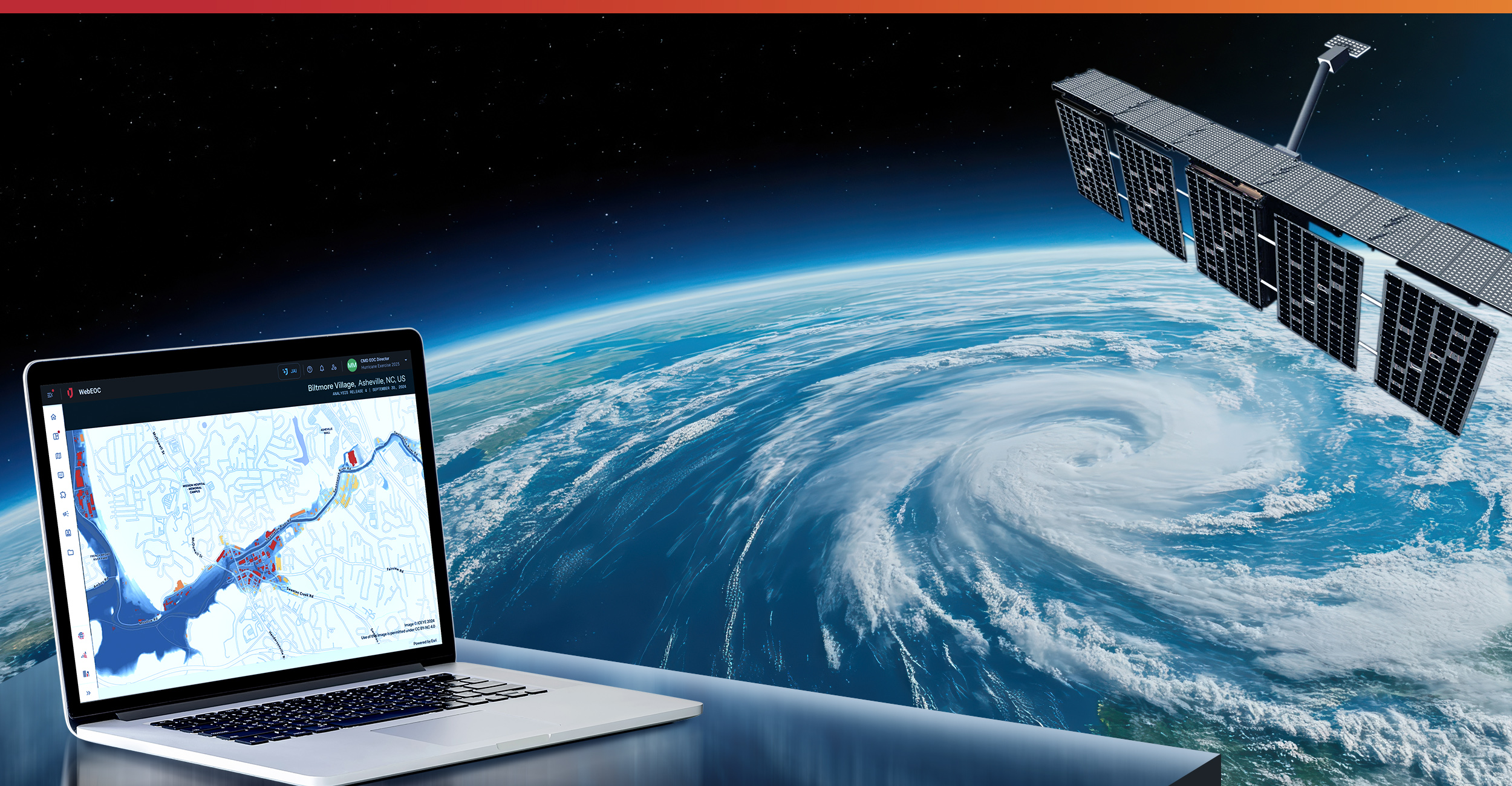
ICEYE: Real-Time Flood Mapping
ICEYE provides synthetic aperture radar (SAR) satellite imagery that cuts through clouds and darkness to deliver accurate flood extents—regardless of conditions on the ground. This is vital when gauges are overwhelmed or inaccessible, as seen in Kerr County TX and Ruidoso NM. Integrated into WebEOC, ICEYE enables incident commanders to visualize submerged areas and adjust operations in near real-time.
WeatherOptics: Predictive Impact Modeling
WeatherOptics connects rainfall forecasts with sector-specific risk analysis, helping responders anticipate which roads, hospitals, or utilities will be affected before the water arrives. In North Carolina, where flood risks extended well beyond the storm’s initial path, predictive modeling made it possible to proactively shift resources and reroute emergency vehicles.
Baron Weather: Live Hazard Tracking
Baron Weather supplies live radar, lightning detection, and storm alerts directly within WebEOC. When flash floods unfold in a matter of hours, this real-time visibility helps agencies stay ahead of the storm—activating alerts, updating incident data, and keeping teams informed every step of the way.
FleetUp: Real-Time Asset Visibility
FleetUp provides GPS tracking and diagnostics for vehicles, equipment, and other mobile assets. During fast-paced flood operations, this visibility helps emergency managers allocate resources more efficiently, prevent duplication of effort, and ensure that responders can reach critical locations.
Crisis Track: Damage Assessment and FEMA Reimbursement
When you need support after floodwaters recede, Crisis Track becomes essential. Purpose-built for disaster documentation, FEMA Public Assistance (PA), Individual Assistance (IA), and resident self-reporting, Crisis Track streamlines recovery and helps expedite federal reimbursement.
Mobile teams conduct field assessments and upload photos and GPS-tagged data, collect data flows into WebEOC for centralized review and tracking, and FEMA-required reports are quickly generated, reducing administrative delays.
From the moment flooding begins through final reimbursement. Crisis Track helps ensure that no damage is overlooked and recovery moves forward without delay.
Building a Stronger Response for the Future
As the climate shifts and extreme weather events grow more frequent, flood response must evolve. The traditional tools of the past, including disconnected systems, manual tracking, and delayed assessments, are no longer enough.
Juvare is helping agencies close the gap between threat and action by building a system of systems. By combining our platform with trusted partner technologies, we deliver the strongest, most connected solutions for managing disasters. Whether you’re planning for response, managing the chaos, or documenting recovery, our solutions work together to provide the clarity and control you need when every second counts.
Ready to see it in action?
Request a demo to learn how WebEOC, Crisis Track, ICEYE, WeatherOptics, Baron Weather, and FleetUp can transform your flood response and recovery strategy.